


valencisse " chambon"

gerardh
User

Length
9.2 km

Max alt
119 m

Uphill gradient
118 m
Km-Effort
10.7 km

Min alt
68 m

Downhill gradient
116 m
Boucle
Yes
Creation date :
2020-07-14 09:13:09.135
Updated on :
2020-07-14 09:14:52.307
2h30
Difficulty : Very easy

FREE GPS app for hiking
 SityTrail
IGN / Geographical institutes
SityTrail Plus
The world is yours!
About
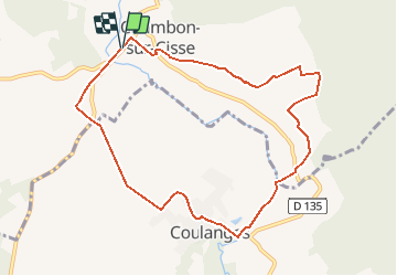
Trail On foot of 9.2 km to be discovered at Centre-Loire Valley, Loir-et-Cher, Valencisse. This trail is proposed by gerardh.
Description
la gde bigotiere
le pont bourdon
coulanges
Positioning
Country:
France
Region :
Centre-Loire Valley
Department/Province :
Loir-et-Cher
Municipality :
Valencisse
Location:
Unknown
Start:(Dec)
Start:(UTM)
365440 ; 5269038 (31T) N.
Comments