


Goux les Dambelins/St Maurise Colombier

tiene
User
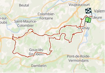

Length
51 km

Max alt
568 m

Uphill gradient
1226 m
Km-Effort
67 km

Min alt
319 m

Downhill gradient
1231 m
Boucle
No
Creation date :
2020-07-14 06:40:08.745
Updated on :
2020-07-14 13:58:51.653
3h29
Difficulty : Medium

FREE GPS app for hiking
 SityTrail
IGN / Geographical institutes
SityTrail Plus
The world is yours!
About
Trail Mountain bike of 51 km to be discovered at Bourgogne-Franche-Comté, Doubs, Mathay. This trail is proposed by tiene.
Positioning
Country:
France
Region :
Bourgogne-Franche-Comté
Department/Province :
Doubs
Municipality :
Mathay
Location:
Unknown
Start:(Dec)
Start:(UTM)
332759 ; 5256160 (32T) N.
Comments