


la doye depuis franchevelle

PatriceCocuaud
User
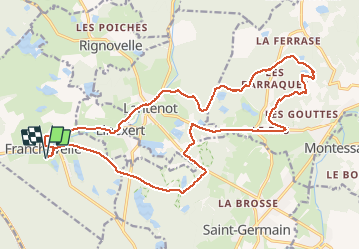

Length
22 km

Max alt
445 m

Uphill gradient
333 m
Km-Effort
27 km

Min alt
291 m

Downhill gradient
334 m
Boucle
Yes
Creation date :
2020-07-14 09:35:47.92
Updated on :
2020-07-14 11:53:38.765
2h17
Difficulty : Medium

FREE GPS app for hiking
 SityTrail
IGN / Geographical institutes
SityTrail Plus
The world is yours!
About
Trail Mountain bike of 22 km to be discovered at Bourgogne-Franche-Comté, Haute-Saône, Franchevelle. This trail is proposed by PatriceCocuaud.
Positioning
Country:
France
Region :
Bourgogne-Franche-Comté
Department/Province :
Haute-Saône
Municipality :
Franchevelle
Location:
Unknown
Start:(Dec)
Start:(UTM)
309548 ; 5290296 (32T) N.
Comments