


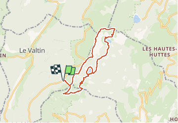
TANET LACS VERT FORLET AR

surceneux
User

Length
15.2 km

Max alt
1300 m

Uphill gradient
621 m
Km-Effort
24 km

Min alt
1048 m

Downhill gradient
629 m
Boucle
Yes
Creation date :
2020-07-14 08:53:16.922
Updated on :
2020-07-14 17:33:20.521
4h00
Difficulty : Medium

FREE GPS app for hiking
 SityTrail
IGN / Geographical institutes
SityTrail Plus
The world is yours!
About
Trail Walking of 15.2 km to be discovered at Grand Est, Vosges, Le Valtin. This trail is proposed by surceneux.
Description
TANET PARKING GAZON DU FAÎTE GAZON DU FAIN LAC DU FORLET LAC VERT SEESTETLE SCHUPFEREN TANET
Positioning
Country:
France
Region :
Grand Est
Department/Province :
Vosges
Municipality :
Le Valtin
Location:
Unknown
Start:(Dec)
Start:(UTM)
354446 ; 5327473 (32U) N.
Comments