


noiretable st laurent sur rochefort

aml63
User
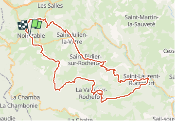

Length
53 km

Max alt
1080 m

Uphill gradient
1883 m
Km-Effort
78 km

Min alt
423 m

Downhill gradient
1889 m
Boucle
Yes
Creation date :
2020-07-14 20:50:13.534
Updated on :
2020-07-14 20:52:08.121
4h58
Difficulty : Very difficult

FREE GPS app for hiking
 SityTrail
IGN / Geographical institutes
SityTrail Plus
The world is yours!
About
Trail Mountain bike of 53 km to be discovered at Auvergne-Rhône-Alpes, Loire, Noirétable. This trail is proposed by aml63.
Positioning
Country:
France
Region :
Auvergne-Rhône-Alpes
Department/Province :
Loire
Municipality :
Noirétable
Location:
Unknown
Start:(Dec)
Start:(UTM)
559411 ; 5074015 (31T) N.
Comments