Trail Walking Noalhat - Noalhat_Autour - Photo
 jagarnier
jagarnier

User GUIDE

© OpenStreetMap contributors
Length
Length
9.3 km
Max alt
Max alt
374 m
Uphill gradient
Uphill gradient
120 m
Km-Effort
Km-Effort  
10.9 km
Min alt
Min alt
282 m
Downhill gradient
Downhill gradient
121 m
Boucle
Boucle
Yes
Creation date :
2020-07-15 07:01:42.755
Updated on :
2025-05-27 09:01:31.498

(0 Reviews)

Walking
Walking
2h30
Difficulty : Easy

Scan this QR Code to open this trail in the SityTrail application

FREE GPS app for hiking

Logo SityTrail SityTrail

IGN / Geographical institutes

Download SityTrail from the App Store Download SityTrail from Google Play

Logo SityTrail SityTrail Plus

The world is yours!

Download SityTrail from the App Store Download SityTrail from Google Play Download SityTrail on Huawei AppGallery

About

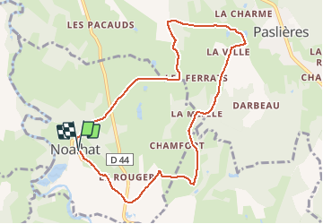
Trail Walking of 9.3 km to be discovered at Auvergne-Rhône-Alpes, Puy-de-Dôme, Noalhat. This trail is proposed by jagarnier.

Description

Cette randonnée vous permettra de découvrir le petit patrimoine de la commune de Noalhat ainsi que l’église de Paslières.
Cette église Notre Dame, érigée en 1690,  fait partie d'un ancien prieuré bénédictin. Son cloché en arcades a été construit en 1859.

Elevation profile

Photos

Positioning

Country:
France
Region :
Auvergne-Rhône-Alpes
Department/Province :
Puy-de-Dôme
Municipality :
Noalhat
Location:
Unknown
Start:(UTM)
535484 ; 5084761 (31T) N.


Close
My subscriptions