Trail Walking Gif-sur-Yvette - ADAL_20140205_GifSurYvette - Photo

ADAL_20140205_GifSurYvette

 VVerley
VVerley

User

© OpenStreetMap contributors
Length
Length
8.4 km
Max alt
Max alt
168 m
Uphill gradient
Uphill gradient
141 m
Km-Effort
Km-Effort  
10.3 km
Min alt
Min alt
64 m
Downhill gradient
Downhill gradient
141 m
Boucle
Boucle
Yes
Creation date :
2014-12-10 00:00:00.0
Updated on :
2014-12-10 00:00:00.0

(1 Reviews)

Walking
Walking
2h15
Difficulty : Very easy

Scan this QR Code to open this trail in the SityTrail application

FREE GPS app for hiking

Logo SityTrail SityTrail

IGN / Geographical institutes

Download SityTrail from the App Store Download SityTrail from Google Play

Logo SityTrail SityTrail World

The world is yours!

Download SityTrail from the App Store Download SityTrail from Google Play Download SityTrail on Huawei AppGallery

About

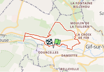
Trail Walking of 8.4 km to be discovered at Ile-de-France, Essonne, Gif-sur-Yvette. This trail is proposed by VVerley.

Elevation profile

Positioning

Country:
France
Region :
Ile-de-France
Department/Province :
Essonne
Municipality :
Gif-sur-Yvette
Location:
Unknown
Start:(UTM)
434251 ; 5394629 (31U) N.

Comments

Please log in to post a review or rate the element


Très bien par temps pluvieux car le chemin est bien drainé.Attention il n'est plus possible de franchir la voie SNCF à pied pour rejoindre le GR 655


Trails nearby

Trail Walking Saint-Rémy-lès-Chevreuse - _Entre vallées et châteaux - Photo
Walking
GUIDE+

Walking

Medium
(13)
Saint-Rémy-lès-Chevreuse, Ile-de-France, Yvelines, France
7.8 km | 9.6 km-effort
2h 0min
Yes
Trail Walking Chevreuse - _La balade de tous les plaisirs - Photo
Walking
GUIDE+

Walking

Easy
(8)
Chevreuse, Ile-de-France, Yvelines, France
5.5 km | 7 km-effort
1h 30min
Yes
Trail Walking Chevreuse - _Sur les pas de Racine (première partie) - Photo
Walking
GUIDE+

Walking

Easy
(7)
Chevreuse, Ile-de-France, Yvelines, France
10.7 km | 14.5 km-effort
2h 30min
Yes
Trail Walking Gif-sur-Yvette - _Gif sur Yvette, une ville à la campagne - Photo
Walking
GUIDE+

Walking

Medium
(3)
Gif-sur-Yvette, Ile-de-France, Essonne, France
8.6 km | 10.5 km-effort
2h 0min
Yes
Trail Walking Magny-les-Hameaux - _La Vallée de la Mérantaise - Photo
Walking
GUIDE+

Walking

Easy
(5)
Magny-les-Hameaux, Ile-de-France, Yvelines, France
9.7 km | 11.6 km-effort
2h 30min
Yes
Trail Walking Gometz-le-Châtel - Autour de Gometz le Châtel - Photo
Walking
tracegps

Walking

Medium
(1)
Gometz-le-Châtel, Ile-de-France, Essonne, France
7.8 km | 10.6 km-effort
2h 30min
Yes
Trail Walking Châteaufort - gitane à  Chateaufort  - Photo
Walking
philou91

Walking

Easy
(1)
Châteaufort, Ile-de-France, Yvelines, France
6.4 km | 7.7 km-effort
2h 3min
Yes
Trail Walking Bures-sur-Yvette - PR 9 Fauvettes - Photo
Walking
JacquesTB

Walking

Very easy
(1)
Bures-sur-Yvette, Ile-de-France, Essonne, France
6.6 km | 8.5 km-effort
2h 3min
Yes
Trail Walking Milon-la-Chapelle - Yvelines_Milon-La-Chapelle=>Chemins_Beauregard&Jean-Racine=>Chevreuse - Photo
Walking
BMorin91470

Walking

Easy
(1)
Milon-la-Chapelle, Ile-de-France, Yvelines, France
9.3 km | 12.7 km-effort
1h 56min
Yes


Close
My subscriptions