


pierre percee

Liebeaux
User
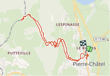

Length
7.1 km

Max alt
1247 m

Uphill gradient
341 m
Km-Effort
11.7 km

Min alt
925 m

Downhill gradient
344 m
Boucle
Yes
Creation date :
2020-07-15 09:21:35.089
Updated on :
2020-07-15 12:41:32.837
3h19
Difficulty : Very easy

FREE GPS app for hiking
 SityTrail
IGN / Geographical institutes
SityTrail Plus
The world is yours!
About
Trail Walking of 7.1 km to be discovered at Auvergne-Rhône-Alpes, Isère, Pierre-Châtel. This trail is proposed by Liebeaux.
Positioning
Country:
France
Region :
Auvergne-Rhône-Alpes
Department/Province :
Isère
Municipality :
Pierre-Châtel
Location:
Unknown
Start:(Dec)
Start:(UTM)
719042 ; 4982046 (31T) N.
Comments