


canyon du gueulard

meillon
User
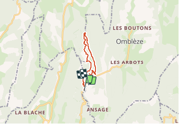

Length
10.2 km

Max alt
830 m

Uphill gradient
424 m
Km-Effort
15.5 km

Min alt
585 m

Downhill gradient
324 m
Boucle
No
Creation date :
2020-07-15 08:38:35.828
Updated on :
2020-07-15 14:24:03.246
3h18
Difficulty : Medium

FREE GPS app for hiking
 SityTrail
IGN / Geographical institutes
SityTrail Plus
The world is yours!
About
Trail Walking of 10.2 km to be discovered at Auvergne-Rhône-Alpes, Drôme, Plan-de-Baix. This trail is proposed by meillon.
Description
on découvre quelques passages sublimes de crocs et de falaises...à voir absolument
Positioning
Country:
France
Region :
Auvergne-Rhône-Alpes
Department/Province :
Drôme
Municipality :
Plan-de-Baix
Location:
Unknown
Start:(Dec)
Start:(UTM)
672998 ; 4967354 (31T) N.
Comments