


ROC DE CUZEAU DEPUIS LE CAMPING

walrou63
User
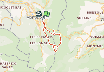

Length
10 km

Max alt
1725 m

Uphill gradient
516 m
Km-Effort
16.9 km

Min alt
1279 m

Downhill gradient
516 m
Boucle
Yes
Creation date :
2020-07-15 17:11:13.071
Updated on :
2020-08-24 15:01:50.646
4h00
Difficulty : Difficult

FREE GPS app for hiking
 SityTrail
IGN / Geographical institutes
SityTrail Plus
The world is yours!
About
Trail On foot of 10 km to be discovered at Auvergne-Rhône-Alpes, Puy-de-Dôme, Mont-Dore. This trail is proposed by walrou63.
Positioning
Country:
France
Region :
Auvergne-Rhône-Alpes
Department/Province :
Puy-de-Dôme
Municipality :
Mont-Dore
Location:
Unknown
Start:(Dec)
Start:(UTM)
485792 ; 5046533 (31T) N.
Comments