


Raccourci Loriots Californie

jmheydorff
User
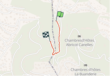

Length
656 m

Max alt
214 m

Uphill gradient
9 m
Km-Effort
846 m

Min alt
178 m

Downhill gradient
30 m
Boucle
No
Creation date :
2020-07-16 05:13:36.0
Updated on :
2020-07-16 05:22:35.659
9m
Difficulty : Easy

FREE GPS app for hiking
 SityTrail
IGN / Geographical institutes
SityTrail Plus
The world is yours!
About
Trail Walking of 656 m to be discovered at Provence-Alpes-Côte d'Azur, Var, Hyères. This trail is proposed by jmheydorff.
Positioning
Country:
France
Region :
Provence-Alpes-Côte d'Azur
Department/Province :
Var
Municipality :
Hyères
Location:
Unknown
Start:(Dec)
Start:(UTM)
264556 ; 4775312 (32T) N.
Comments