


11688085-track-1594921160-16

HG74250
User
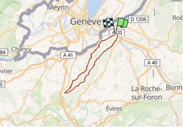

Length
39 km

Max alt
1335 m

Uphill gradient
1591 m
Km-Effort
60 km

Min alt
403 m

Downhill gradient
1595 m
Boucle
Yes
Creation date :
2020-07-16 17:44:08.832
Updated on :
2024-04-30 18:38:13.417
4h11
Difficulty : Very difficult

FREE GPS app for hiking
 SityTrail
IGN / Geographical institutes
SityTrail Plus
The world is yours!
About
Trail Mountain bike of 39 km to be discovered at Auvergne-Rhône-Alpes, Upper Savoy, Étrembières. This trail is proposed by HG74250.
Positioning
Country:
France
Region :
Auvergne-Rhône-Alpes
Department/Province :
Upper Savoy
Municipality :
Étrembières
Location:
Unknown
Start:(Dec)
Start:(UTM)
286004 ; 5117445 (32T) N.
Comments