


SityTrail - 2472972 - min-2020-j1-tourer

olivieraron
User
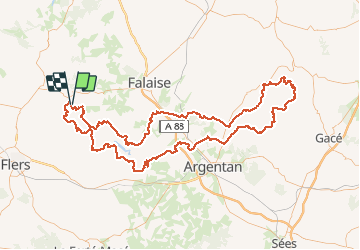

Length
174 km

Max alt
277 m

Uphill gradient
2754 m
Km-Effort
211 km

Min alt
51 m

Downhill gradient
2759 m
Boucle
Yes
Creation date :
2020-07-17 08:04:16.0
Updated on :
2020-07-17 08:05:48.023

FREE GPS app for hiking
 SityTrail
IGN / Geographical institutes
SityTrail Plus
The world is yours!
About
Trail of 174 km to be discovered at Normandy, Orne, Ménil-Hubert-sur-Orne. This trail is proposed by olivieraron.
Positioning
Country:
France
Region :
Normandy
Department/Province :
Orne
Municipality :
Ménil-Hubert-sur-Orne
Location:
Unknown
Start:(Dec)
Start:(UTM)
689853 ; 5414544 (30U) N.
Comments