


Cols des Moises, du Feu, des Arces - 18932 - UtagawaVTT.com

HG74250
User
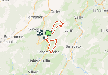

Length
21 km

Max alt
1366 m

Uphill gradient
855 m
Km-Effort
33 km

Min alt
998 m

Downhill gradient
853 m
Boucle
Yes
Creation date :
2020-07-17 15:50:50.727
Updated on :
2020-07-17 15:58:09.263
2h04
Difficulty : Medium

FREE GPS app for hiking
 SityTrail
IGN / Geographical institutes
SityTrail Plus
The world is yours!
About
Trail Mountain bike of 21 km to be discovered at Auvergne-Rhône-Alpes, Upper Savoy, Habère-Poche. This trail is proposed by HG74250.
Positioning
Country:
France
Region :
Auvergne-Rhône-Alpes
Department/Province :
Upper Savoy
Municipality :
Habère-Poche
Location:
Unknown
Start:(Dec)
Start:(UTM)
304613 ; 5126999 (32T) N.
Comments