


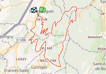
Taille de la Marquise - 23384 - UtagawaVTT.com

HG74250
User

Length
28 km

Max alt
1436 m

Uphill gradient
1034 m
Km-Effort
42 km

Min alt
534 m

Downhill gradient
1035 m
Boucle
Yes
Creation date :
2020-07-17 15:52:08.545
Updated on :
2020-07-20 18:17:27.951
2h39
Difficulty : Difficult

FREE GPS app for hiking
 SityTrail
IGN / Geographical institutes
SityTrail Plus
The world is yours!
About
Trail Mountain bike of 28 km to be discovered at Auvergne-Rhône-Alpes, Upper Savoy, Saint-Cergues. This trail is proposed by HG74250.
Positioning
Country:
France
Region :
Auvergne-Rhône-Alpes
Department/Province :
Upper Savoy
Municipality :
Saint-Cergues
Location:
Unknown
Start:(Dec)
Start:(UTM)
293183 ; 5123191 (32T) N.
Comments