


20200717 Les Granges

Childebert
User
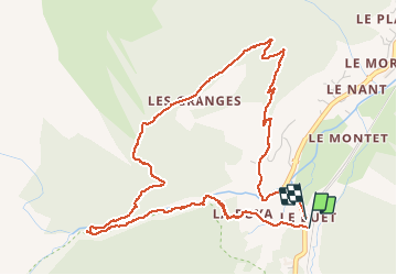

Length
5.9 km

Max alt
1597 m

Uphill gradient
266 m
Km-Effort
9.5 km

Min alt
1336 m

Downhill gradient
274 m
Boucle
Yes
Creation date :
2020-07-17 11:46:57.368
Updated on :
2020-07-17 16:47:10.149
3h18
Difficulty : Medium

FREE GPS app for hiking
 SityTrail
IGN / Geographical institutes
SityTrail Plus
The world is yours!
About
Trail Walking of 5.9 km to be discovered at Auvergne-Rhône-Alpes, Upper Savoy, Vallorcine. This trail is proposed by Childebert.
Positioning
Country:
France
Region :
Auvergne-Rhône-Alpes
Department/Province :
Upper Savoy
Municipality :
Vallorcine
Location:
Unknown
Start:(Dec)
Start:(UTM)
338997 ; 5098207 (32T) N.
Comments