


Nans-sous-Sainte-Anne_Montmahoux 17.7km 20200719

cmike39
User
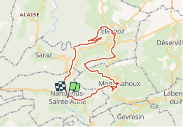

Length
17.7 km

Max alt
820 m

Uphill gradient
567 m
Km-Effort
25 km

Min alt
358 m

Downhill gradient
567 m
Boucle
Yes
Creation date :
2020-07-19 07:40:27.07
Updated on :
2022-07-18 13:17:28.952
4h21
Difficulty : Very easy

FREE GPS app for hiking
 SityTrail
IGN / Geographical institutes
SityTrail Plus
The world is yours!
About
Trail Walking of 17.7 km to be discovered at Bourgogne-Franche-Comté, Doubs, Nans-sous-Sainte-Anne. This trail is proposed by cmike39.
Positioning
Country:
France
Region :
Bourgogne-Franche-Comté
Department/Province :
Doubs
Municipality :
Nans-sous-Sainte-Anne
Location:
Unknown
Start:(Dec)
Start:(UTM)
728121 ; 5206928 (31T) N.
Comments