


Verlée, Buzin, Jeneffe, Verlée

FouargePatrick
User
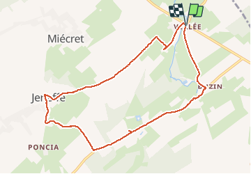

Length
8.8 km

Max alt
324 m

Uphill gradient
118 m
Km-Effort
10.4 km

Min alt
266 m

Downhill gradient
118 m
Boucle
Yes
Creation date :
2020-07-19 11:03:28.0
Updated on :
2020-07-19 16:57:29.983
2h26
Difficulty : Very easy

FREE GPS app for hiking
 SityTrail
IGN / Geographical institutes
SityTrail Plus
The world is yours!
About
Trail Walking of 8.8 km to be discovered at Wallonia, Namur, Havelange. This trail is proposed by FouargePatrick.
Description
Randonée dans le Condroz autour de Havelange. Peut d'ombre sur le tracé.
Photos


Positioning
Country:
Belgium
Region :
Wallonia
Department/Province :
Namur
Municipality :
Havelange
Location:
Verlée
Start:(Dec)
Start:(UTM)
662095 ; 5582003 (31U) N.
Comments