


2020-07-20 Col du Pigeonnier-Chapelle Climbach-Col du Piegeonnier

maureengeorges
User
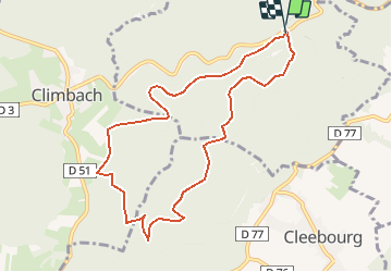

Length
8.8 km

Max alt
486 m

Uphill gradient
232 m
Km-Effort
11.9 km

Min alt
397 m

Downhill gradient
231 m
Boucle
Yes
Creation date :
2020-07-20 12:15:32.948
Updated on :
2020-07-20 12:16:41.675
2h31
Difficulty : Medium

FREE GPS app for hiking
 SityTrail
IGN / Geographical institutes
SityTrail Plus
The world is yours!
About
Trail Walking of 8.8 km to be discovered at Grand Est, Bas-Rhin, Wissembourg. This trail is proposed by maureengeorges.
Positioning
Country:
France
Region :
Grand Est
Department/Province :
Bas-Rhin
Municipality :
Wissembourg
Location:
Unknown
Start:(Dec)
Start:(UTM)
418530 ; 5430790 (32U) N.
Comments