


col beal

ppn
User
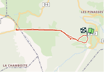

Length
7.9 km

Max alt
1402 m

Uphill gradient
280 m
Km-Effort
11.7 km

Min alt
1147 m

Downhill gradient
282 m
Boucle
Yes
Creation date :
2020-07-21 08:16:16.934
Updated on :
2020-07-21 11:30:42.488
3h03
Difficulty : Very easy

FREE GPS app for hiking
 SityTrail
IGN / Geographical institutes
SityTrail Plus
The world is yours!
About
Trail Walking of 7.9 km to be discovered at Auvergne-Rhône-Alpes, Loire, Chalmazel-Jeansagnière. This trail is proposed by ppn.
Positioning
Country:
France
Region :
Auvergne-Rhône-Alpes
Department/Province :
Loire
Municipality :
Chalmazel-Jeansagnière
Location:
Chalmazel
Start:(Dec)
Start:(UTM)
564219 ; 5059045 (31T) N.
Comments