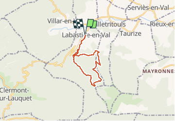
Trail Walking Labastide-en-Val - Labastide-En-val - Photo
 mikaou.t
mikaou.t

User

© OpenStreetMap contributors
Length
Length
11 km
Max alt
Max alt
647 m
Uphill gradient
Uphill gradient
406 m
Km-Effort
Km-Effort  
16.4 km
Min alt
Min alt
245 m
Downhill gradient
Downhill gradient
406 m
Boucle
Boucle
Yes
Creation date :
2020-07-20 08:10:41.813
Updated on :
2020-07-21 14:32:02.239

(0 Reviews)

Walking
Walking
3h25
Difficulty : Medium

Scan this QR Code to open this trail in the SityTrail application

FREE GPS app for hiking

Logo SityTrail SityTrail

IGN / Geographical institutes

Download SityTrail from the App Store Download SityTrail from Google Play

Logo SityTrail SityTrail Plus

The world is yours!

Download SityTrail from the App Store Download SityTrail from Google Play Download SityTrail on Huawei AppGallery

About

Trail Walking of 11 km to be discovered at Occitania, Aude, Labastide-en-Val. This trail is proposed by mikaou.t.

Description

Départ du pont à côté de l'église.
Circuit balisé en jaune. A la fin du circuit, le tracé poursuit sur la large piste forestière afin de passer à proximité du barrage sur la rivière et rejoint ensuite le chemin du départ afin d'éviter la route bitumée.

Elevation profile

Points of interest

Point of interest Villetritouls - Point de vue et table d'orientation - Photo
mikaou.t

Positioning

Country:
France
Region :
Occitania
Department/Province :
Aude
Municipality :
Labastide-en-Val
Location:
Unknown
Start:(UTM)
457094 ; 4769336 (31T) N.


Close
My subscriptions