


chagny-chamilly-tumuli dolmens

XavierFaidix
User
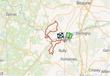

Length
48 km

Max alt
492 m

Uphill gradient
1163 m
Km-Effort
64 km

Min alt
212 m

Downhill gradient
1164 m
Boucle
Yes
Creation date :
2020-07-21 06:30:53.669
Updated on :
2020-07-21 12:21:26.118
4h20
Difficulty : Difficult

FREE GPS app for hiking
 SityTrail
IGN / Geographical institutes
SityTrail Plus
The world is yours!
About
Trail Mountain bike of 48 km to be discovered at Bourgogne-Franche-Comté, Saône-et-Loire, Chagny. This trail is proposed by XavierFaidix.
Positioning
Country:
France
Region :
Bourgogne-Franche-Comté
Department/Province :
Saône-et-Loire
Municipality :
Chagny
Location:
Unknown
Start:(Dec)
Start:(UTM)
633476 ; 5195758 (31T) N.
Comments