


Randonnée Mont sur Marchienne

jackcox
User
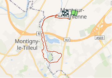

Length
7.1 km

Max alt
152 m

Uphill gradient
112 m
Km-Effort
8.5 km

Min alt
106 m

Downhill gradient
111 m
Boucle
Yes
Creation date :
2020-07-21 17:46:26.968
Updated on :
2020-07-21 17:51:08.585
1h51
Difficulty : Medium

FREE GPS app for hiking
 SityTrail
IGN / Geographical institutes
SityTrail Plus
The world is yours!
About
Trail Walking of 7.1 km to be discovered at Wallonia, Hainaut, Charleroi. This trail is proposed by jackcox.
Description
Départ place Roger Desaise direction Montigny le tilleul en revenant le long de l'Eau d'Heure
Positioning
Country:
Belgium
Region :
Wallonia
Department/Province :
Hainaut
Municipality :
Charleroi
Location:
Mont-sur-Marchienne
Start:(Dec)
Start:(UTM)
599770 ; 5582693 (31U) N.
Comments