


SDMl1MApbJw

babeth35
User
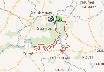

Length
16 km

Max alt
95 m

Uphill gradient
287 m
Km-Effort
19.8 km

Min alt
25 m

Downhill gradient
283 m
Boucle
Yes
Creation date :
2020-07-22 03:34:58.165
Updated on :
2020-07-22 03:46:18.765
--
Difficulty : Unknown

FREE GPS app for hiking
 SityTrail
IGN / Geographical institutes
SityTrail Plus
The world is yours!
About
Trail Walking of 16 km to be discovered at Brittany, Côtes-d'Armor, Guenroc. This trail is proposed by babeth35.
Points of interest

Positioning
Country:
France
Region :
Brittany
Department/Province :
Côtes-d'Armor
Municipality :
Guenroc
Location:
Unknown
Start:(Dec)
Start:(UTM)
569470 ; 5352305 (30U) N.
Comments