


RIGAUD - Rigaud > col de Mairola

JMHRX2
User
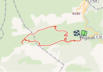

Length
9.5 km

Max alt
1325 m

Uphill gradient
728 m
Km-Effort
19.2 km

Min alt
609 m

Downhill gradient
724 m
Boucle
Yes
Creation date :
2020-07-21 06:57:49.161
Updated on :
2020-07-22 06:16:30.243
3h08
Difficulty : Very easy

FREE GPS app for hiking
 SityTrail
IGN / Geographical institutes
SityTrail Plus
The world is yours!
About
Trail Walking of 9.5 km to be discovered at Provence-Alpes-Côte d'Azur, Maritime Alps, Rigaud. This trail is proposed by JMHRX2.
Positioning
Country:
France
Region :
Provence-Alpes-Côte d'Azur
Department/Province :
Maritime Alps
Municipality :
Rigaud
Location:
Unknown
Start:(Dec)
Start:(UTM)
338576 ; 4872661 (32T) N.
Comments