


nant cote larzac

CASSISFRAMBOISE
User

Length
23 km

Max alt
807 m

Uphill gradient
546 m
Km-Effort
30 km

Min alt
514 m

Downhill gradient
551 m
Boucle
Yes
Creation date :
2020-07-21 07:05:28.876
Updated on :
2020-07-22 16:56:45.506
7h51
Difficulty : Difficult

FREE GPS app for hiking
 SityTrail
IGN / Geographical institutes
SityTrail Plus
The world is yours!
About
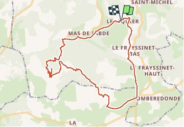
Trail Walking of 23 km to be discovered at Occitania, Aveyron, Nant. This trail is proposed by CASSISFRAMBOISE.
Photos


Positioning
Country:
France
Region :
Occitania
Department/Province :
Aveyron
Municipality :
Nant
Location:
Unknown
Start:(Dec)
Start:(UTM)
524105 ; 4871913 (31T) N.
Comments