Trail Walking Polignac - Circuit autour de POLIGNAC - Photo

Circuit autour de POLIGNAC

© OpenStreetMap contributors
Length
Length
8.7 km
Max alt
Max alt
810 m
Uphill gradient
Uphill gradient
202 m
Km-Effort
Km-Effort  
11.4 km
Min alt
Min alt
668 m
Downhill gradient
Downhill gradient
206 m
Boucle
Boucle
Yes
Creation date :
2020-07-22 08:34:08.0
Updated on :
2020-07-22 11:16:31.84

(1 Reviews)

Walking
Walking
2h21
Difficulty : Easy

Scan this QR Code to open this trail in the SityTrail application

FREE GPS app for hiking

Logo SityTrail SityTrail

IGN / Geographical institutes

Download SityTrail from the App Store Download SityTrail from Google Play

Logo SityTrail SityTrail World

The world is yours!

Download SityTrail from the App Store Download SityTrail from Google Play Download SityTrail on Huawei AppGallery

About

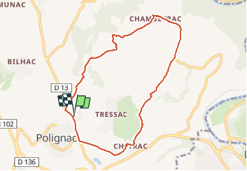
Trail Walking of 8.7 km to be discovered at Auvergne-Rhône-Alpes, Haute-Loire, Polignac. This trail is proposed by Jean-MarieFaux.

Description

Circuit plus court que celui de la dentelière mais qui permet de faire une promenade tôt le matin

Elevation profile

Photos

Positioning

Country:
France
Region :
Auvergne-Rhône-Alpes
Department/Province :
Haute-Loire
Municipality :
Polignac
Location:
Unknown
Start:(UTM)
568050 ; 4991359 (31T) N.

Comments

Please log in to post a review or rate the element


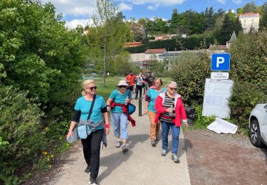
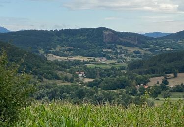
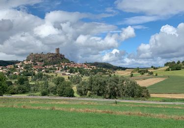
Belle balade avec un peu de dénivelé et sous un soleil radieux.


Trails nearby

Trail Walking Le Puy-en-Velay - Compostelle : 1-Le Puy en Vely - St Didier d'Allier - Photo
Walking
prv

Walking

Very easy
(1)
Le Puy-en-Velay, Auvergne-Rhône-Alpes, Haute-Loire, France
31 km | 41 km-effort
8h 54min
No
Trail Walking Le Puy-en-Velay - Puy en velay - St Privat d'Allier - Chemin de Compostelle - Photo
Walking
tracegps

Walking

Very difficult
(2)
Le Puy-en-Velay, Auvergne-Rhône-Alpes, Haute-Loire, France
24 km | 32 km-effort
6h 4min
No
Trail Walking Le Puy-en-Velay - Le Puy Saugue Avril 2018 - Photo
Walking
GUIDE
Kargil

Walking

Difficult
Le Puy-en-Velay, Auvergne-Rhône-Alpes, Haute-Loire, France
44 km | 62 km-effort
13h 51min
No
Trail Walking Polignac - Polignac-La Source_9,7 km - Photo
Walking
Pousscailleux

Walking

Medium
(2)
Polignac, Auvergne-Rhône-Alpes, Haute-Loire, France
9.7 km | 13.8 km-effort
3h 8min
Yes
Trail Walking Le Puy-en-Velay - Compostelle 5 GR65 - Photo
Walking
Landreger

Walking

Medium
(4)
Le Puy-en-Velay, Auvergne-Rhône-Alpes, Haute-Loire, France
115 km | 154 km-effort
Unknown
No
Trail Walking Polignac - Polignac  - Photo
Walking
boyer43

Walking

Very difficult
(1)
Polignac, Auvergne-Rhône-Alpes, Haute-Loire, France
22 km | 30 km-effort
6h 47min
Yes
Trail Walking Le Puy-en-Velay - Circuit parcours Coeur et Ssnte - Photo
Walking
Jean-MarieFaux

Walking

Le Puy-en-Velay, Auvergne-Rhône-Alpes, Haute-Loire, France
6.1 km | 6.5 km-effort
1h 26min
Yes
Trail Road bike Aiguilhe - Voie verte au Puy en Velay - Photo
Road bike
pauldurand

Road bike

Medium
Aiguilhe, Auvergne-Rhône-Alpes, Haute-Loire, France
34 km | 41 km-effort
3h 38min
No
Trail Walking Aiguilhe - 2020 CHEMIN DE LA RÉGORDANE: Visite au château de Polygnac - Photo
Walking
LEGUE

Walking

Aiguilhe, Auvergne-Rhône-Alpes, Haute-Loire, France
7 km | 10.2 km-effort
2h 16min
No


Close
My subscriptions