


Sclucht sentier des roches

Steinier
User
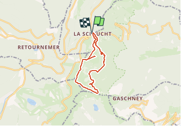

Length
11.5 km

Max alt
1338 m

Uphill gradient
474 m
Km-Effort
17.8 km

Min alt
967 m

Downhill gradient
472 m
Boucle
Yes
Creation date :
2020-07-22 08:27:44.0
Updated on :
2020-07-22 13:33:44.32
3h54
Difficulty : Very difficult

FREE GPS app for hiking
 SityTrail
IGN / Geographical institutes
SityTrail Plus
The world is yours!
About
Trail Walking of 11.5 km to be discovered at Grand Est, Vosges, Le Valtin. This trail is proposed by Steinier.
Positioning
Country:
France
Region :
Grand Est
Department/Province :
Vosges
Municipality :
Le Valtin
Location:
Unknown
Start:(Dec)
Start:(UTM)
352668 ; 5325330 (32U) N.
Comments
Une randonnée ludique avec un départ aménagé, qui nous fait découvrir des cirques puis les grands espaces des sommets des Vosges. Couleurs magnifiques en automne et vue sur les Alpes par beau temps au sommet du Honeck!
Difficile Magnifique