


saint pal en chalancon

psesjs
User
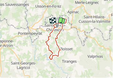

Length
24 km

Max alt
973 m

Uphill gradient
638 m
Km-Effort
32 km

Min alt
696 m

Downhill gradient
639 m
Boucle
Yes
Creation date :
2020-07-22 07:47:20.448
Updated on :
2020-07-22 15:22:33.063
5h37
Difficulty : Easy

FREE GPS app for hiking
 SityTrail
IGN / Geographical institutes
SityTrail Plus
The world is yours!
About
Trail Walking of 24 km to be discovered at Auvergne-Rhône-Alpes, Haute-Loire, Saint-Pal-de-Chalencon. This trail is proposed by psesjs.
Positioning
Country:
France
Region :
Auvergne-Rhône-Alpes
Department/Province :
Haute-Loire
Municipality :
Saint-Pal-de-Chalencon
Location:
Unknown
Start:(Dec)
Start:(UTM)
575283 ; 5022925 (31T) N.
Comments