


Malaucène - Les 3 combes

Nathy8913
User
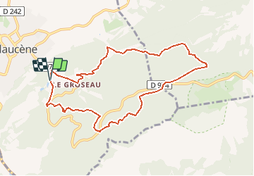

Length
9.5 km

Max alt
769 m

Uphill gradient
497 m
Km-Effort
16.1 km

Min alt
377 m

Downhill gradient
499 m
Boucle
Yes
Creation date :
2020-07-22 16:12:10.541
Updated on :
2020-07-22 16:12:19.252

FREE GPS app for hiking
 SityTrail
IGN / Geographical institutes
SityTrail Plus
The world is yours!
About
Trail of 9.5 km to be discovered at Provence-Alpes-Côte d'Azur, Vaucluse, Malaucène. This trail is proposed by Nathy8913.


Positioning
Country:
France
Region :
Provence-Alpes-Côte d'Azur
Department/Province :
Vaucluse
Municipality :
Malaucène
Location:
Unknown
Start:(Dec)
Start:(UTM)
671245 ; 4892728 (31T) N.
Comments