


Parilly 23 07 20 - 4.2km--1h05 - 3.9km/h

jtraverse
User
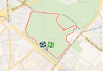

Length
4.2 km

Max alt
199 m

Uphill gradient
34 m
Km-Effort
4.7 km

Min alt
182 m

Downhill gradient
41 m
Boucle
Yes
Creation date :
2020-07-23 06:05:31.699
Updated on :
2020-07-30 09:10:24.213
1h05
Difficulty : Very easy

FREE GPS app for hiking
 SityTrail
IGN / Geographical institutes
SityTrail Plus
The world is yours!
About
Trail Walking of 4.2 km to be discovered at Auvergne-Rhône-Alpes, Métropole de Lyon, Vénissieux. This trail is proposed by jtraverse.
Description
Rééducation genou droit
Positioning
Country:
France
Region :
Auvergne-Rhône-Alpes
Department/Province :
Métropole de Lyon
Municipality :
Vénissieux
Location:
Unknown
Start:(Dec)
Start:(UTM)
647811 ; 5064026 (31T) N.
Comments