


eaunes sentiers fait 2020

pidjam
User
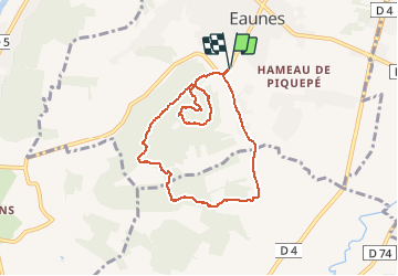

Length
7.7 km

Max alt
294 m

Uphill gradient
177 m
Km-Effort
10.1 km

Min alt
208 m

Downhill gradient
177 m
Boucle
Yes
Creation date :
2020-07-23 07:47:06.023
Updated on :
2020-07-23 09:53:33.313
2h05
Difficulty : Easy

FREE GPS app for hiking
 SityTrail
IGN / Geographical institutes
SityTrail Plus
The world is yours!
About
Trail Walking of 7.7 km to be discovered at Occitania, Haute-Garonne, Eaunes. This trail is proposed by pidjam.
Positioning
Country:
France
Region :
Occitania
Department/Province :
Haute-Garonne
Municipality :
Eaunes
Location:
Unknown
Start:(Dec)
Start:(UTM)
366652 ; 4808657 (31T) N.
Comments