


via ferrata Picassass + Monte Crocino Alpe Vedabia lac Majeur Baveno

ManteR07
User
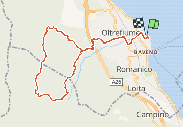

Length
11.8 km

Max alt
1011 m

Uphill gradient
850 m
Km-Effort
23 km

Min alt
200 m

Downhill gradient
849 m
Boucle
Yes
Creation date :
2020-07-23 07:52:29.267
Updated on :
2020-07-23 14:25:50.452
3h50
Difficulty : Very easy

FREE GPS app for hiking
 SityTrail
IGN / Geographical institutes
SityTrail Plus
The world is yours!
About
Trail Via ferrata of 11.8 km to be discovered at Piemont, Verbano-Cusio-Ossola, Baveno. This trail is proposed by ManteR07.
Positioning
Country:
Italy
Region :
Piemont
Department/Province :
Verbano-Cusio-Ossola
Municipality :
Baveno
Location:
Unknown
Start:(Dec)
Start:(UTM)
461644 ; 5084466 (32T) N.
Comments