


autun balade P Gonnet

XavierFaidix
User

Length
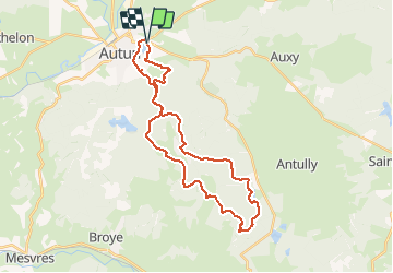
32 km

Max alt
616 m

Uphill gradient
613 m
Km-Effort
40 km

Min alt
302 m

Downhill gradient
613 m
Boucle
Yes
Creation date :
2020-07-23 07:03:54.565
Updated on :
2020-07-23 14:58:05.741
3h05
Difficulty : Medium

FREE GPS app for hiking
 SityTrail
IGN / Geographical institutes
SityTrail Plus
The world is yours!
About
Trail Mountain bike of 32 km to be discovered at Bourgogne-Franche-Comté, Saône-et-Loire, Autun. This trail is proposed by XavierFaidix.
Positioning
Country:
France
Region :
Bourgogne-Franche-Comté
Department/Province :
Saône-et-Loire
Municipality :
Autun
Location:
Saint-Pantaléon
Start:(Dec)
Start:(UTM)
600242 ; 5201052 (31T) N.
Comments