


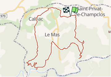
30 - SAINT-PRIVAT-DE-CHAMPCLOS - 12.8 Km - 05h00 – D 390 m

dansmabulle
User

Length
12.7 km

Max alt
254 m

Uphill gradient
388 m
Km-Effort
17.9 km

Min alt
108 m

Downhill gradient
387 m
Boucle
Yes
Creation date :
2014-12-10 00:00:00.0
Updated on :
2014-12-10 00:00:00.0
3h47
Difficulty : Difficult

FREE GPS app for hiking
 SityTrail
IGN / Geographical institutes
SityTrail Plus
The world is yours!
About
Trail Walking of 12.7 km to be discovered at Occitania, Gard, Saint-Privat-de-Champclos. This trail is proposed by dansmabulle.
Positioning
Country:
France
Region :
Occitania
Department/Province :
Gard
Municipality :
Saint-Privat-de-Champclos
Location:
Unknown
Start:(Dec)
Start:(UTM)
608302 ; 4904410 (31T) N.
Comments