


30 - SERVIERS – AUBUSSARGUES - 16.2 Km - 05h00 - D 270 m

dansmabulle
User
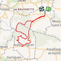

Length
16.3 km

Max alt
205 m

Uphill gradient
271 m
Km-Effort
19.9 km

Min alt
101 m

Downhill gradient
271 m
Boucle
Yes
Creation date :
2014-12-10 00:00:00.0
Updated on :
2014-12-10 00:00:00.0
4h19
Difficulty : Difficult

FREE GPS app for hiking
 SityTrail
IGN / Geographical institutes
SityTrail Plus
The world is yours!
About
Trail Walking of 16.3 km to be discovered at Occitania, Gard, Serviers-et-Labaume. This trail is proposed by dansmabulle.
Positioning
Country:
France
Region :
Occitania
Department/Province :
Gard
Municipality :
Serviers-et-Labaume
Location:
Unknown
Start:(Dec)
Start:(UTM)
608642 ; 4877081 (31T) N.
Comments