


retour aire

Bwattier
User
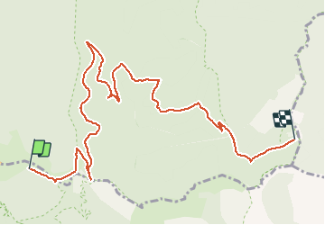

Length
10.7 km

Max alt
1541 m

Uphill gradient
139 m
Km-Effort
14.1 km

Min alt
995 m

Downhill gradient
586 m
Boucle
No
Creation date :
2020-07-14 12:18:03.402
Updated on :
2020-07-24 10:29:24.586
2h57
Difficulty : Very easy

FREE GPS app for hiking
 SityTrail
IGN / Geographical institutes
SityTrail Plus
The world is yours!
About
Trail Walking of 10.7 km to be discovered at Occitania, Gard, Val-d'Aigoual. This trail is proposed by Bwattier.
Positioning
Country:
France
Region :
Occitania
Department/Province :
Gard
Municipality :
Val-d'Aigoual
Location:
Valleraugue
Start:(Dec)
Start:(UTM)
546641 ; 4885459 (31T) N.
Comments