


tourmalet G2 heit

LouisROGER
User GUIDE
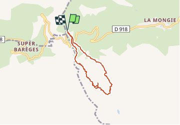

Length
5.5 km

Max alt
2357 m

Uphill gradient
455 m
Km-Effort
11.6 km

Min alt
1983 m

Downhill gradient
458 m
Boucle
Yes
Creation date :
2020-07-24 07:15:56.86
Updated on :
2020-07-29 09:20:58.922
6h37
Difficulty : Very easy

FREE GPS app for hiking
 SityTrail
IGN / Geographical institutes
SityTrail Plus
The world is yours!
About
Trail Walking of 5.5 km to be discovered at Occitania, Hautespyrenees, Bagnères-de-Bigorre. This trail is proposed by LouisROGER.
Description
tout plein de chaos et rocailleux.
Photos


Positioning
Country:
France
Region :
Occitania
Department/Province :
Hautespyrenees
Municipality :
Bagnères-de-Bigorre
Location:
Unknown
Start:(Dec)
Start:(UTM)
267031 ; 4754688 (31T) N.
Comments