


taïgaMardi

RANDOPS
User
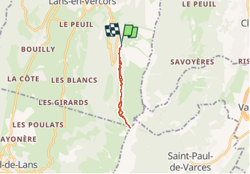

Length
10 km

Max alt
1738 m

Uphill gradient
371 m
Km-Effort
14.9 km

Min alt
1407 m

Downhill gradient
367 m
Boucle
Yes
Creation date :
2014-12-10 00:00:00.0
Updated on :
2014-12-10 00:00:00.0
4h57
Difficulty : Easy

FREE GPS app for hiking
 SityTrail
IGN / Geographical institutes
SityTrail Plus
The world is yours!
About
Trail Snowshoes of 10 km to be discovered at Auvergne-Rhône-Alpes, Isère, Lans-en-Vercors. This trail is proposed by RANDOPS.
Description
Col de l'Arc
Positioning
Country:
France
Region :
Auvergne-Rhône-Alpes
Department/Province :
Isère
Municipality :
Lans-en-Vercors
Location:
Unknown
Start:(Dec)
Start:(UTM)
705208 ; 4998657 (31T) N.
Comments