


redon

mcterret
User
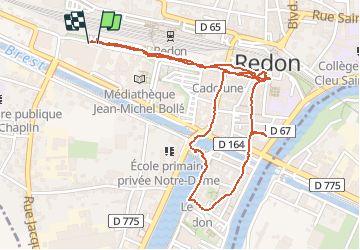

Length
2.6 km

Max alt
18 m

Uphill gradient
27 m
Km-Effort
3 km

Min alt
2 m

Downhill gradient
27 m
Boucle
Yes
Creation date :
2020-07-25 09:10:24.357
Updated on :
2020-07-25 10:35:50.802
1h25
Difficulty : Very easy

FREE GPS app for hiking
 SityTrail
IGN / Geographical institutes
SityTrail Plus
The world is yours!
About
Trail Walking of 2.6 km to be discovered at Brittany, Ille-et-Vilaine, Redon. This trail is proposed by mcterret.
Positioning
Country:
France
Region :
Brittany
Department/Province :
Ille-et-Vilaine
Municipality :
Redon
Location:
Unknown
Start:(Dec)
Start:(UTM)
568224 ; 5277981 (30T) N.
Comments