


gerardmer

robjor1946
User

Length
17.6 km

Max alt
967 m

Uphill gradient
968 m
Km-Effort
30 km

Min alt
658 m

Downhill gradient
836 m
Boucle
No
Creation date :
2020-07-25 07:21:01.103
Updated on :
2020-07-25 13:27:29.155
3h54
Difficulty : Very easy

FREE GPS app for hiking
 SityTrail
IGN / Geographical institutes
SityTrail Plus
The world is yours!
About
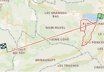
Trail Walking of 17.6 km to be discovered at Grand Est, Vosges, Gérardmer. This trail is proposed by robjor1946.
Description
facile
Positioning
Country:
France
Region :
Grand Est
Department/Province :
Vosges
Municipality :
Gérardmer
Location:
Unknown
Start:(Dec)
Start:(UTM)
340339 ; 5325767 (32U) N.
Comments