


Pic St Michel ski rando

psesjs
User
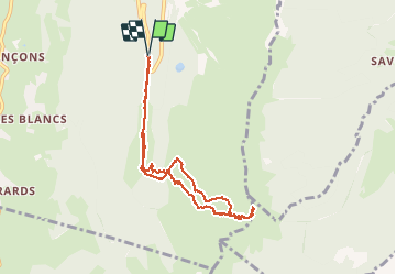

Length
8.1 km

Max alt
1965 m

Uphill gradient
653 m
Km-Effort
16.8 km

Min alt
1294 m

Downhill gradient
654 m
Boucle
Yes
Creation date :
2014-12-10 00:00:00.0
Updated on :
2021-02-11 18:26:22.683
--
Difficulty : Easy

FREE GPS app for hiking
 SityTrail
IGN / Geographical institutes
SityTrail Plus
The world is yours!
About
Trail Touring skiing of 8.1 km to be discovered at Auvergne-Rhône-Alpes, Isère, Lans-en-Vercors. This trail is proposed by psesjs.
Positioning
Country:
France
Region :
Auvergne-Rhône-Alpes
Department/Province :
Isère
Municipality :
Lans-en-Vercors
Location:
Unknown
Start:(Dec)
Start:(UTM)
704829 ; 4998149 (31T) N.
Comments