


Croutoy

fitz2014
User
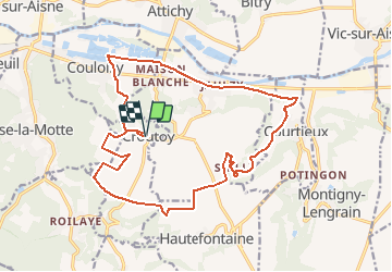

Length
18.4 km

Max alt
151 m

Uphill gradient
189 m
Km-Effort
21 km

Min alt
34 m

Downhill gradient
188 m
Boucle
Yes
Creation date :
2020-07-26 10:49:42.802
Updated on :
2020-08-05 09:23:51.663
3h53
Difficulty : Difficult

FREE GPS app for hiking
 SityTrail
IGN / Geographical institutes
SityTrail Plus
The world is yours!
About
Trail Walking of 18.4 km to be discovered at Hauts-de-France, Oise, Croutoy. This trail is proposed by fitz2014.
Positioning
Country:
France
Region :
Hauts-de-France
Department/Province :
Oise
Municipality :
Croutoy
Location:
Unknown
Start:(Dec)
Start:(UTM)
503026 ; 5470359 (31U) N.
Comments