


RIF 1-07-2020 du 25/07/20

bene_dictus77
User

Length
18.8 km

Max alt
183 m

Uphill gradient
282 m
Km-Effort
23 km

Min alt
111 m

Downhill gradient
282 m
Boucle
Yes
Creation date :
2020-07-26 08:15:24.034
Updated on :
2020-07-26 14:41:22.933
5h42
Difficulty : Very easy

FREE GPS app for hiking
 SityTrail
IGN / Geographical institutes
SityTrail Plus
The world is yours!
About
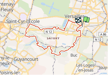
Trail Walking of 18.8 km to be discovered at Ile-de-France, Yvelines, Versailles. This trail is proposed by bene_dictus77.
Description
Autour de Versailles
Positioning
Country:
France
Region :
Ile-de-France
Department/Province :
Yvelines
Municipality :
Versailles
Location:
Unknown
Start:(Dec)
Start:(UTM)
436499 ; 5405128 (31U) N.
Comments