


le derochoir

Bernadette Noirant
User
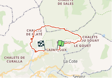

Length
12.9 km

Max alt
2350 m

Uphill gradient
1127 m
Km-Effort
28 km

Min alt
1237 m

Downhill gradient
1202 m
Boucle
No
Creation date :
2020-07-26 07:53:17.355
Updated on :
2020-07-26 18:09:03.73
7h00
Difficulty : Difficult

FREE GPS app for hiking
 SityTrail
IGN / Geographical institutes
SityTrail Plus
The world is yours!
About
Trail Walking of 12.9 km to be discovered at Auvergne-Rhône-Alpes, Upper Savoy, Passy. This trail is proposed by Bernadette Noirant.
Description
beau varié
Positioning
Country:
France
Region :
Auvergne-Rhône-Alpes
Department/Province :
Upper Savoy
Municipality :
Passy
Location:
Unknown
Start:(Dec)
Start:(UTM)
325003 ; 5091079 (32T) N.
Comments