Trail Walking Sauclières - saucliéres 12 - Photo
© OpenStreetMap contributors
Length
Length
14.5 km
Max alt
Max alt
906 m
Uphill gradient
Uphill gradient
415 m
Km-Effort
Km-Effort  
20 km
Min alt
Min alt
704 m
Downhill gradient
Downhill gradient
417 m
Boucle
Boucle
Yes
Creation date :
2014-12-10 00:00:00.0
Updated on :
2014-12-10 00:00:00.0

(0 Reviews)

Walking
Walking
4h14
Difficulty : Medium

Scan this QR Code to open this trail in the SityTrail application

FREE GPS app for hiking

Logo SityTrail SityTrail

IGN / Geographical institutes

Download SityTrail from the App Store Download SityTrail from Google Play

Logo SityTrail SityTrail World

The world is yours!

Download SityTrail from the App Store Download SityTrail from Google Play Download SityTrail on Huawei AppGallery

About

Trail Walking of 14.5 km to be discovered at Occitania, Aveyron, Sauclières. This trail is proposed by pipette12.

Description

de saucliéres à gaillac commune de la couvertoirade à la perte de la virenque et retour au départ

Elevation profile

Positioning

Country:
France
Region :
Occitania
Department/Province :
Aveyron
Municipality :
Sauclières
Location:
Unknown
Start:(UTM)
528801 ; 4868928 (31T) N.

Trails nearby

Trail Walking Sauclières - Sauciers le causse de campestre  - Photo
Walking
vidalou

Walking

Difficult
Sauclières, Occitania, Aveyron, France
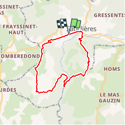
16.9 km | 22 km-effort
5h 37min
No
Trail Mountain bike Nant - Fait GTMC 2022 E8 Millau  3,5 b - Photo
Mountain bike
jl77130

Mountain bike

Difficult
Nant, Occitania, Aveyron, France
58 km | 69 km-effort
7h 51min
No
Trail On foot Campestre-et-Luc - Le Causse de Campestre - Photo
On foot
PRO

On foot

Easy
Campestre-et-Luc, Occitania, Gard, France
14.3 km | 18.9 km-effort
4h 17min
Yes
Trail Walking Nant - nant cote larzac - Photo
Walking
CASSISFRAMBOISE

Walking

Difficult
Nant, Occitania, Aveyron, France
23 km | 30 km-effort
7h 51min
Yes
Trail Walking Sauclières - Sauclières, passage à la perte de la Virenque, le Pouget, retour Sauclières - Photo
Walking
Mathieu Causse

Walking

Medium
Sauclières, Occitania, Aveyron, France
11.8 km | 16.5 km-effort
1h 53min
Yes
Trail Mountain bike Sauclières - Sauclières Algues Le liquier Sauclières - Photo
Mountain bike
Mathieu Causse

Mountain bike

Medium
Sauclières, Occitania, Aveyron, France
25 km | 34 km-effort
2h 19min
Yes
Trail Walking Sauclières - Sauclières (causse de Campestre) - Photo
Walking
coulombf

Walking

Easy
Sauclières, Occitania, Aveyron, France
16.9 km | 23 km-effort
5h 25min
Yes
Trail Walking Nant - Larzac3 Nant - La Couvertoirade - Photo
Walking
pcugnod

Walking

Easy
Nant, Occitania, Aveyron, France
16.1 km | 22 km-effort
5h 36min
No
Trail Walking Sauclières - Perte de la Virenque - Photo
Walking
Pierre11

Walking

Easy
Sauclières, Occitania, Aveyron, France
11.1 km | 15.9 km-effort
3h 21min
No


Close
My subscriptions