


Longemer lispach

Steinier
User
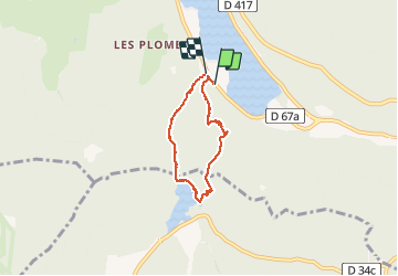

Length
5 km

Max alt
1012 m

Uphill gradient
283 m
Km-Effort
8.7 km

Min alt
750 m

Downhill gradient
282 m
Boucle
Yes
Creation date :
2020-07-27 08:55:28.0
Updated on :
2020-07-27 10:54:50.521
1h58
Difficulty : Difficult

FREE GPS app for hiking
 SityTrail
IGN / Geographical institutes
SityTrail Plus
The world is yours!
About
Trail Walking of 5 km to be discovered at Grand Est, Vosges, Xonrupt-Longemer. This trail is proposed by Steinier.
Positioning
Country:
France
Region :
Grand Est
Department/Province :
Vosges
Municipality :
Xonrupt-Longemer
Location:
Unknown
Start:(Dec)
Start:(UTM)
347206 ; 5325733 (32U) N.
Comments