


roc de peyremaux/stéle des aviateurs

Dupleix
User
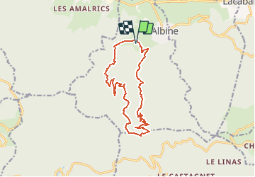

Length
15.5 km

Max alt
997 m

Uphill gradient
694 m
Km-Effort
25 km

Min alt
377 m

Downhill gradient
695 m
Boucle
Yes
Creation date :
2020-07-27 15:04:46.905
Updated on :
2020-07-27 15:13:48.312
--
Difficulty : Difficult

FREE GPS app for hiking
 SityTrail
IGN / Geographical institutes
SityTrail Plus
The world is yours!
About
Trail On foot of 15.5 km to be discovered at Occitania, Tarn, Albine. This trail is proposed by Dupleix.
Description
boucle au dessus d'albine:
on montera par le circiit balisé du roc et descendrons par le sentier balisé de la rando de wibault
Positioning
Country:
France
Region :
Occitania
Department/Province :
Tarn
Municipality :
Albine
Location:
Unknown
Start:(Dec)
Start:(UTM)
461731 ; 4811489 (31T) N.
Comments