


Wikiloc - Chapelle clape

pidjam
User

Length
13.5 km

Max alt
72 m

Uphill gradient
177 m
Km-Effort
15.9 km

Min alt
-1 m

Downhill gradient
174 m
Boucle
Yes
Creation date :
2020-07-28 13:02:04.738
Updated on :
2020-11-29 09:22:50.683
3h28
Difficulty : Difficult

FREE GPS app for hiking
 SityTrail
IGN / Geographical institutes
SityTrail Plus
The world is yours!
About
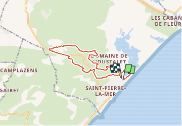
Trail Walking of 13.5 km to be discovered at Occitania, Aude, Fleury. This trail is proposed by pidjam.
Positioning
Country:
France
Region :
Occitania
Department/Province :
Aude
Municipality :
Fleury
Location:
Unknown
Start:(Dec)
Start:(UTM)
516094 ; 4781562 (31T) N.
Comments