


Pernes les Fontaines

kephas
User
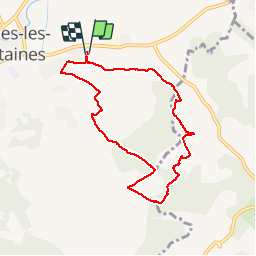

Length
8 km

Max alt
203 m

Uphill gradient
124 m
Km-Effort
9.7 km

Min alt
97 m

Downhill gradient
126 m
Boucle
Yes
Creation date :
2014-12-10 00:00:00.0
Updated on :
2014-12-10 00:00:00.0
2h23
Difficulty : Easy

FREE GPS app for hiking
 SityTrail
IGN / Geographical institutes
SityTrail Plus
The world is yours!
About
Trail Walking of 8 km to be discovered at Provence-Alpes-Côte d'Azur, Vaucluse, Pernes-les-Fontaines. This trail is proposed by kephas.
Positioning
Country:
France
Region :
Provence-Alpes-Côte d'Azur
Department/Province :
Vaucluse
Municipality :
Pernes-les-Fontaines
Location:
Unknown
Start:(Dec)
Start:(UTM)
666241 ; 4873662 (31T) N.
Comments
belle rando à travers la forêt les vignes les oliviers